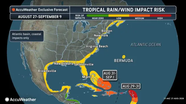
The National Hurricane Center named Tropical Storm Dolly at 11:00 AM AST on Thursday, August 27, roughly 1,555 miles east of the Leeward Islands. Maximum sustained winds were near 40 mph with a central pressure of 1007 mb, and the system was racing west at 24 mph. No coastal watches or warnings were in effect at the time of the first advisory.
Forecasters expect Dolly to be short lived. Dry air, hostile wind shear, and interaction with the islands are all working against it, and the NHC forecast has the storm degenerating into a tropical wave before it reaches the Leewards this weekend. The Caribbean should still see 1 to 4 inches of rain, with locally higher totals in mountainous terrain and a flash flood risk across Puerto Rico, the Virgin Islands, and Hispaniola from late Saturday into Monday. Some model guidance keeps the door open for the remnants to reorganize near the Bahamas or off the Southeast coast mid to late next week.
That is the forecast. Here is the part that matters more for anyone responsible for keeping a facility running.
The Numbers Behind the Quiet
Dolly is only the fourth named storm of the 2026 Atlantic hurricane season, following Arthur, Bertha, and Cristobal. There have been zero hurricanes. It is the slowest start to an Atlantic season in nearly four decades.
The reason is a record-setting El Nino. Water temperatures in the El Nino monitoring region are running about 2.07 degrees Celsius above average, stronger than the comparable point in the 2015, 1997, 1991, and 1982 events. Some models suggest it could end up the strongest El Nino since 1950. El Nino drives wind shear across the Atlantic basin, and shear tears developing storms apart. That is exactly what is expected to happen to Dolly.
NOAA’s August update reflected it. The agency trimmed its outlook to 7 to 13 named storms, 2 to 6 hurricanes, and 0 to 2 major hurricanes, down from the May forecast, and raised the odds of a below normal season from 55 percent to 75 percent.
Three quarters odds of a quiet season is a real forecast. It is also the single most dangerous number on this page, because of what people do with it.
Quiet Seasons Still Produce Catastrophes
Seasonal totals do not make landfall. Individual storms do, and it only takes one.
1983 produced four named storms all year, one of the quietest seasons on record, during a super El Nino. One of those four was Alicia, which came ashore near Galveston as a Category 3 and did billions in damage across the Houston metro.
1992 produced six named storms in a below normal, El Nino influenced season. The first one was Andrew, a Category 5 that flattened Homestead, Florida and remained the costliest hurricane in US history for well over a decade.
Both seasons would have been correctly forecast as below normal. Both are remembered for a single storm that changed a region permanently.
The climatological peak of the Atlantic season is September 10. We are two weeks out from it. A below normal season with an active September is still a season with an active September, and El Nino patterns can weaken or shift in ways that open windows for development, particularly closer to home in the Gulf and off the Southeast coast where storms have less time to be sheared apart before landfall.
What Gulf Coast and Florida Facilities Should Be Doing Right Now
The gap between a quiet forecast and an unready generator is where outage losses happen. If your standby power has not been exercised under real conditions this summer, Dolly is a free reminder, not a threat.
Load bank test your standby units. A no load or light load monthly exercise proves the engine starts. It does not prove the unit can carry the building. Wet stacking from chronic underloading is one of the most common reasons a generator fails during an actual event. NFPA 110 calls for annual load testing for a reason.
Check fuel quantity, quality, and contracts. Diesel degrades. Microbial growth and water intrusion in tanks that sit for months are routine findings. Confirm your fuel polishing schedule, verify tank levels against your required runtime, and get your emergency fuel delivery agreement in writing before a storm is named, not after.
Test the transfer switch, not just the generator. An ATS that does not transfer is a full outage regardless of how well the engine runs. Exercise it under load and verify the time delays and return sequence.
Confirm your service response before the queue forms. Every service provider in the Southeast is oversubscribed in the 72 hours before landfall. Coverage secured in August is worth considerably more than a phone call in September.
Know your rental fallback. If your primary unit fails or your load has grown past it, know now what size you would need, where it would come from, and how long delivery takes. Rental fleets in Florida and the Gulf tighten fast once a system enters the basin.
Document runtime requirements. Hospitals, data centers, lift stations, cold storage, and telecom sites all have different tolerances. Know exactly how many hours you need to cover and whether your fuel on site actually supports it.
The Takeaway
Dolly will most likely be a footnote, a tropical wave delivering needed rain to islands that have been dry. That is the good outcome, and it is the one to hope for.
But the 2026 season has produced four named storms and no hurricanes, and that record is quietly training people to relax two weeks before the peak. September is also National Preparedness Month. The facilities that come through the next eight weeks intact will be the ones that treated a slow August as free time to get ready rather than evidence that they did not need to.
Generator Source sells, services, rents, and buys commercial and industrial generators from 20kW to 4MW+, with branches in Jacksonville and Pensacola, Florida, Austin, Texas, and headquarters in Brighton, Colorado. If your standby power has not been load tested this season, or you want a rental contingency in place before the peak, contact our Florida team to schedule an assessment.
Still have questions or looking for more information?
Generator Source specializes in low-hour, used, new, and surplus generator sets. We have a wide variety of generator sizes and models to fit any project. We are not a broker, we own what we sell.
Call us today (877-866-6895) or click Contact Us to be connected with one of our experienced sales reps.
We have 350+ generators in stock and ready to ship!